|
|
|
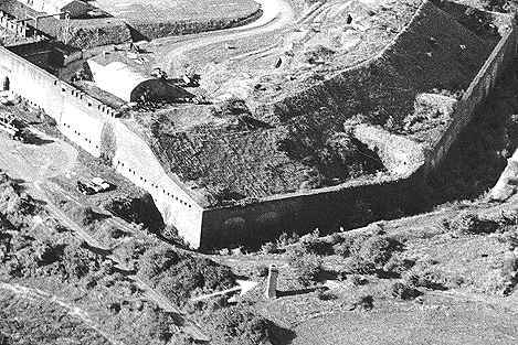
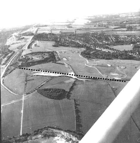
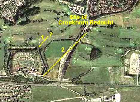
Over the years I
have received a lot of email giving fragmentary accounts of a another
tunnel running northeast (towards Crookhorn Redoubt) from Fort Purbrook.
During March 2003 I was sent an un-solicited and very detailed e-mail from
a retired Ordnance Surveyor who unknowingly confirmed all the previous
information, added some more, and supplied 8/10 figure map references. The
correspondence indicates that Fort Purbrook, Farlington Redoubt and
Crookhorn Redoubt are connected by a system of connecting tunnels.
Here are extracts from some of the e-mails:
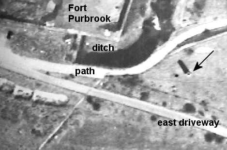
...this
was in about 1951/52. An openable manhole a few
yards east of the old route of Crookhorn Lane gave access
to a square brick-lined shaft, about 20 feet deep. The shaft was equipped
with staple-shaped iron rungs set into the brickwork. I have to be somewhat
vague about the actual location but it was well north of the forts at
about
SU6828 0665. The tunnel then went in a south westerly direction ending at
a similar shaft adjacent to the eastern driveway to Fort
Purbrook. This shaft
extended
upwards into a 15 foot high, square, brick chimney, perhaps the "air
shaft" marked on the pre-war 1/10560 (6 inches to the
mile) Ordnance Survey map. Exit from this shaft was
only possible because at the time there was a hole
in the brickwork just big enough to scramble through. The position of this
air shaft on the pre-war map was SU67998 06337, that is to
the north of the drive and 16 metres from the south
eastern corner of the moat...
...this
[the tunnel] was cut directly into the chalk with no brickwork. It was
about 7 feet high and about 3 or 4 feet wide. The floor was unpaved and
contained a 6 inch iron pipe...
...working
from the contours and spot heights on the Ordnance Survey 1/25000
map,
I estimate that the tunnel (not counting the extension mentioned above)
was
450 yards long with a rise of 33 feet, giving a gradient of 1 in 42...
Shaun
McGrath
|
|
| ... I descended into the tunnel in the very early
1950s. At the time the shaft at the Crookhorn end was only
covered by a removable slab that could be easily slid away.
This then led into the shaft which had staple-like foot rests to
descend on. At the base of the shaft the tunnel led away
both to the north and south. The main part of the tunnel was
to the south in the direction of Fort Purbrook...
...the tunnel was standing height for an adult and about four
feet wide. Along the base ran a metal pipe. At various
point along the tunnel were ventilation shafts to the surface.
These were purely for ventilation it appears and there was no
provision for ascending to the surface. Near to the south east of Fort Purbrook the tunnel had clearly been deliberately
blocked probably to prevent entrance to Fort Purbrook itself.
This was the point to where there was another ascent shaft which
at ground level led into a high chimney. An entrance/exit
way had been broken through the chimney at ground level.
Importantly, probably, where the continuation into the Fort had
been blocked there was some evidence of further deliberate
blocking. Could this have been the T-junction to Farlington
Redoubt?...
...I need to mention too that the tunnel did not terminate at the
foot of the Crookhorn end but continued to the north. We
rarely went along this length because if was very much smaller
head height and restricted width. This was probably because
of the considerable sloping of the ground at surface level.
Several times we did though and continued about 150 yards where
again there further much shorter shaft to the surface. This
was near the bomb crater now on Crookhorn Golf Course as a pond...
John
Knight
|
|
|
...in
the early 1970s, when the redoubt [Farlington Redoubt] was fully
decommissioned and handed over to British Gas
as a depot, my friends and I were always in and out
of the fort [Purbrook] and the redoubt, and
on one occasion the tunnel between was
uncovered by bulldozers in the floor of the redoubt and 2
of my friends followed the tunnel right through to the old ventilation
shaft/chimney (now gone) just off the
South-East corner of the fort [Purbrook]...
Alan
Dominey
|
|
| ...I have been
trying to find more evidence for the possibility of there being a
tunnel from Purbrook to Farlington and have come across the
following piece from a newspaper article of 1863. It mentions a
sunken gallery, which is obviously a tunnel as it is also used to
describe the communications from the main part of Purbrook to its Caponiers
and mortar batteries. More interesting is the fact that the tunnel
to Farlington went via Crookhorn. When Crookhorn was demolished
this would obviously have severed the tunnel to Farlington. This
would also remove the argument that there could not be a tunnel to
Farlington from Purbrook because of the low cutting between the
two. Here is the piece:
Illustrated
Times September 26 1863
At
the east end of the hill the works are the least forward of any,
but here may be seen the unusually formidable nature of the trace?‘
It is commanded by three works Farlington, Crookhorn, and
Purbrook. All three have yet proceeded in their construction but
little beyond their formation of parapet and ditch and general
outline. Their height reaches -300ft. above Ordnance level.
Farlington commands the eastern point of Portsdown, and will mount
eighteen of the heaviest guns on its terre-plein, with
mortar-batteries in the angles of its surrounding ditches, each
battery mounting three mortars. A sunken gallery communicates with
Crookhorn, which will mount sixteen guns on its terre-plein, with
six guns in the angles of its ditch. A continuation of the same
sunken gallery leads from Crookhorn to the main work at this
eastern end of Portsdown -Purbrook which will mount twenty-one
guns on its terre-plein, nine guns in caponieres [sic] in the
ditch, and three mortars in the ditch‘s west angle. It has a
nearly straight face of 240ft., looking inland; the open gorge
being opposite the west side of Langstone Harbour. The ditches
surrounding the three works vary in depth according to their
position from 35ft. to 50ft. Sunken galleries from the interior of
the works communicate with the mortar batteries and caponieres in
the ditches.
David
Moore - Palmerston
Forts Society
|
|
|
...I
spoke with my chum yesterday and it would seem that the tunnel nr
Fort Purbrook is in a different location than I imagined. The
chimney was to the SE of the fort and would have been there when
he was young in the 40s. He said it was of a
square construction with an opening that was later obstructed with
bars, these were eventually bent back by someone or other. From
the opening there were curved rungs set into the chalk that led
down about 12-20 feet. The tunnel led off
eastward a short distance and longer to the west, both blocked.
He remembers that the chimney was demolished after
some time...
John
Wood
|
|
|
|
I grew up during the Second World War in Drayton, and in 1945 when the war ended; I was just ten years old. I was the normal healthy, adventurous lad and, together with my friends, Malcolm Thornton, Albert Kirby, and Peter Good, we would venture up onto Portsdown Hill exploring places as youngsters do.
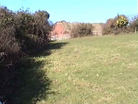
In our explorations, we discovered the vent chimney to the south east of the fort, but of course, as young boys, we had no idea what it was for.
In the eastern face of the square chimney, we found that bars in the large grill built into the face had been forced apart, and we were able to climb through and descend the iron rungs set in the chalk walls below.
Our first excursion down into the chimney led us to discover the small tunnel hewn out of the chalk and running northwest from the fort. In the opposite chalk face was a locked door, which we assumed led back into the fort itself.
Later explorations there saw us armed with torches and candles with which to light our way and explore the tunnel further.
I was of average height and build as a lad, but I recall the tunnel being narrow and with a low roof, causing us to have to bend at times as we found our way along it. The tunnel eventually led out into a large concrete pit in a field to the east of the old Crookhorn Lane. At intervals along the tunnel, we came across vertical shafts up to the surface through which daylight percolated. These we assumed were air vents. Along the left hand side of the tunnel ran a large black pipe, and we always wondered as to its purpose.
During the war, we had to have gas mask practices, and I have vivid recollections of being forced at school to don the blasted thing. I suffered with claustrophobia at the time and would fight off attempts by the teachers to put one over my face. The tunnel was also claustrophobic, but with my friends, I would fight off the feeling and like to think that these explorations underground helped to practically cure me of the allergy.
Brian Wells
|
|
|
NEW -
24-07-2005
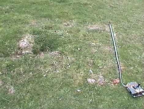
During the late 50s I was a pupil at Purbrook Park School. During games in the afternoon we would opt for 'cross country running' which meant we got off site and went where we wanted. We would usually go to the
[Farlington] Redoubt and mess about and have a fag etc. We had heard the tales of tunnels under the hill, and at the time there was what appeared to be a ventilation chimney on the line from Ft Purbrook to the Redoubt. After a bit of scratching about we removed some of the bricks at ground level (on the blind side of Ft Purbrook!) and found there were iron steps set into the side of a vertical shaft leading down to a tunnel. The tunnel to the West led to a junction with, as I remember it, two other tunnels, one going north east and the other roughly west. These were blocked after a short distance. The tunnel to the east however continued for some distance (200yds?) before again being blocked. The tunnel was about 5'6" high, or slightly more, and was wide enough to walk easily without rubbing the sides too often. The roof of the tunnel varied in height, in some places dropping 6" or so quite smartly, causing a certain amount of swearing because of a banged head! Also for part, if not all of the way there was an iron pipe, about 6" diameter laid along the floor of the tunnel. As the walls tapered in towards the bottom this made walking a little more hazardous.
We only went down 2 or three times, and later our access hole we found had been bricked up again.
Steve Gilbert
|
|
|
NEW -
17-09-2006
Back in the early 1960s I and my friends Ian Knight, Bobby Densham, and
Rob Haines were regular visitors to the tunnels gaining access via the
square brick lined shaft just to the east of Crookhorn Lane. The details
are as others have described them, the section going north was blocked by
lose earth which looked to be a deliberate blockage as the surface soil
was heavy clay. The tunnel was on an alignment to some sunken rooms/
brickwork which had filled up with a clay slippage engulfing the
construction. A few hundred yards north of this construction was a farm
which had the appearance of having been a small army base [the
Crookhorn HAA gun site],
this would have been almost opposite what is now the Centurion Pub. The
family (Green ) who had the farm had a son who attended Purbrook Junior
School with us and he told us of an entrance in the farmyard.
I remember the locations very clearly and armed with a 1950s map of the
lane would have no problem marking out the various places.
Andrew Masson |
|
|
NEW -
07-12-2008
When I was a lad (over half a century ago) I used to play in Farlington
Redoubt and surrounding areas...The redoubt offered young would be
'Cowboys' a John Wayne playground. There was a tunnel (Short) in the face
of the bank facing south which we entered. More interesting was the tunnel
between the wooden wartime camp
at Crookhorn. This was apparently linked to Ft Purbrook by a tunnel
containing pipes etc. It was about 6' high and half as wide. It was
entered (by us lads) via a vertical tube with a built in ladder. The
entrance was marked by 4 posts (much like similar erections between Ft
Southwick and Skew Rd south of James Callahan drive which the farmer
navigated round when ploughing, though whether there are tunnels below
there I don't know). Half way along the Ft Purbrook - Crookhorn tunnel
there had been a collapse, but, undeterred we shimmied through a narrow
opening and eventually found another vertical access close to the Fort. My
memory fails a little here, but I think it emerged in a brick chimney
close to the east side of the Fort. It was probably 20' tall and visible
from Portsdown Hill Rd (above the reservoirs) So, I can categorically
state that one was real...not legendry.
Ian Hunt |
|
|
NEW -
02-01-2009
I was just surfing the net and came across your site. It brought back
memories as a young boy. Back in the early 1960s we used to explore this
tunnel. We gained entrance by a man hole cover, since disappeared – this
was before Crookhorn Lane was straightened, and before the golf course was
built - then down a shaft. The tunnel was at the bottom; one direction
towards the fort the other towards the old army camp (this was then part
of Gauntlett’s Farm; now a housing estate) I hope this might be of some
help.
Terry Barnes |
|
|
NEW -
19-09-2010
|
Have just come across your site re the tunnels. I was born (1944)and
brought up in Purbrook .As a lad, my friends and I spent a lot of our time
playing around the old Farlington redoubt most of it was just huge mounds
of chalk (difficult and dangerous to climb) and as I recall some of them
had the metal gun emplacements at the top, but these could have been AA
sights for the defence of Portsmouth WW11.
BUT. following the track (WEST) from the redoubt across Crookhorn lane
toward Fort Purbrook, there was a brick built chimney measuring i suppose
about 4ftX4ft square just coming up out of the ground. This looked odd and
needed exploring. Then we noticed that there was some fairly newer bricks
in the chimney on one side, I think the North side, these were in a square
about 18" sq. so out with penknives or what ever and removed the newer
bricks.
We then dared one another to have a look inside, all the time trying to
hide from the fort, as we were led to believe there were armed sentries up
there. One of the lads had a battery torch on his bike so that was used to
look inside the chimney, we could see metal rungs inside leading down, the
torch by this time getting pretty dim so we planned to revisit better
equipped.
The next visit we summoned up the courage to enter the chimney and climb
down, at our age 8-9 it seemed a long way down but I suppose it must have
been about 20ft. The coldness and the smell of wet chalk was apparent. On
reaching the bottom we shone our torches around us and saw that the
tunnels went in three directions, we also saw names etched in the chalk.
There were a lot of what looked like steel rods laying around, we could
actually walk upright in the tunnels, one tunnel only went a short
distance 20-25 feet, which went south before it was blocked, the other
tunnel which went a little bit further maybe 30-35 ft in a westerly
direction, but the third which I believe went in a north easterly
direction toward what we knew as the old POW camp in Crookhorn must have
been several hundred yards long before it was blocked by collapse. We
visited the tunnel on quite a few occasions but then became disinterested,
but I know the chimney was still there in the 1960s, it was visible from
the A27 and the railway line.
About 4-5 years ago I was visiting the UK and took my son and 2 grandsons
to Fort Purbrook and told them the story, we went to look for the chimney,
but alas there it was. GONE. Hope this true story is of some help
Peter Parker - September 2010 |
|
|
|
|
I
would like to thank all the contributors to this topic
|
|
|