Legends & Mysteries 

Fort Purbrook - Tunnel No1

 Created 15-07-2002    Last update 08-03-2003

click the arrow


page 1 of 2

>


Forward

If you read the "Various" Legends & Mysteries webpage you will see that the notion of communication tunnels between the Palmerston Forts on Portsdown has been discounted. 

However the case is somewhat different regarding the most eastern of the Portsdown Forts - Fort Purbrook - and its two outposts: Crookhorn Redoubt and Farlington Redoubt. These Redoubts were built to protect the eastern flank of Fort Purbrook and are smaller versions of the Fort proper.

Farlington Redoubt was demolished in various stages up to the 1970s, and is now little more than a hole in the chalk. Crookhorn Redoubt had subsidence problems, and was demolished in the 1870s - today there is absolutely no trace left of this fortification, and even its former boundaries are unclear. Fort Purbrook still exists and is in a fair state of repair.

Because both the Redoubts are now destroyed any evidence of connecting tunnels must now be sought mainly at the Fort Purbrook end. In this account I first deal with Farlington Redoubt then Crookhorn Redoubt, although the evidence is intertwined. Fort Purbrook is dealt with throughout.


Map of Redoubts

Map showing the location of the two Redoubts in relation to Fort Purbrook.

Fort Purbrook SU679064
Crookhorn Redoubt SU682067
Farlington Redoubt SU686064
 

Aerial photo site location     Panoramic photo site location
Google Earth Aerial View

Farlington Redoubt

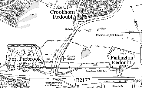
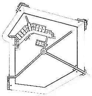
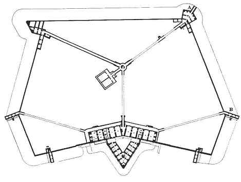
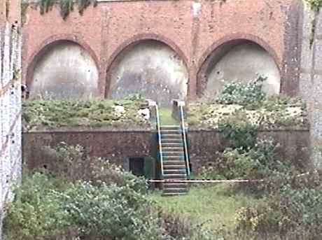
Farlington Redoubt was to have been fitted with barracks and a magazine, together with substantial underground works to protect the ditches and to permit counter-mining (the process by which you defeat an enemies attempt to dig under your fortifications by tunnelling, or mining, towards their tunnels). Rising costs of the other forts caused the plans to be drastically cut back and although the ditches and gun emplacements were provided, little else was done.

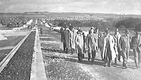
Shortly before World War II, the War Office decided to dispose of the Redoubt and it was duly acquired and put on the market. Seeing the convenience of the position and the huge potential supply of chalk that would arise from quarrying away the central dumpling within the moat, and with a view to the causeway construction of a large part of the Eastern Road (A2030), Fraser & White purchased the Redoubt. A strip of land was also purchased from the War Department so that a new northern access route from Portsdown Hill Road could be constructed - the original access to the Redoubt was from the west. This accounts for the state of the site today.

It was believed that Farlington Redoubt was linked to Fort Purbrook by a tunnel, but no evidence has been found for this at the Purbrook end, where logically it should appear at the end of the Musketry Gallery at the eastern angle, nor is such a tunnel shown on any plan.


Farlington redoubt plan

The lower plan of Farlington Redoubt.

It does not mention anything about a tunnel. However I have seen a reference which states that from the magazine a stairway had been cut through solid chalk to the level of the ditch where it terminated behind masonry facing. This "blind wall" concept is found again in Fort Purbrook.

Copyright David Moore - Palmerston Forts Society


Plan of Fort purbrook

Lower plan of Fort Purbrook. 

'B' is the Musketry Gallery in the east ditch where a tunnel from Farlington Redoubt would be expected to emerge. 

Copyright David Moore - Palmerston Forts Society


Fort Purbrook east Musketry Gallery

The Musketry Gallery in the eastern ditch of Fort Purbrook. To the left (west) is the Scarp of Fort Purbrook, and to the right (east) the Counter Scarp.


Inside east gallery

Inside the Musketry Gallery in the eastern ditch of Fort Purbrook facing towards Farlington Redoubt in the east. The original Victorian brickwork shows no trace of a tunnel ever having existed here. The roof of the Gallery can be seen sloping down to the end wall, and a tunnel portal here would seem improbable. The "blind wall" concept does not apply here. Even if the tunnel was sealed off during construction then breaking down this wall could provoke a roof collapse.


There is an above ground connection between Fort Purbrook and Farlington Redoubt in the form of a covered way. It is shown on the original plans, and still exists in part today. It can been seen on the 1:25000 OS map above. A covered way is an earthwork, near vertical on the defenders side and sloping on the enemies side, about 6 feet high. This allows the protected movement of troops between 2 locations, and also doubles-up as a firing step.


Covered way at Fort Purbrook

A section of the covered way at the north-east of Fort Purbrook, which leads to Farlington Redoubt.


Eastern Road just opened

The Eastern Road being built. The chalk from Farlington Redoubt was used in its construction resulting in the complete destruction of the Outpost. Fort Purbrook can be seen on Portsdown in direct line with the road.


click the arrow


page 1 of 2

>