Legends & Mysteries

Hillsley Road

 Created 03-04-2003   Last update 24-10-2004

click the arrow


page 1 of 3

>


The Hillsley Road Area

Hillsley Road was originally constructed during the late 1930s in the fields of Portsdown as an access road to build and service the Oil Fuel Reservoirs, which are located at its western end. In 1942 the UGHQ underground complex was excavated under Fort Southwick which lies a few hundred yards to the north. Five years later Hillsley Road was incorporated into the post-war Paulsgrove Housing Estate, becoming its north western edge. Finally in the early 1970s the M27 was was built just to the south.

 
Map of the Hillsley Road area
Image produced from the Ordnance Survey Get-a-map service. Image reproduced with kind permission of Ordnance Survey and Ordnance Survey of Northern Ireland.

Aerial photo site location       Google Earth Aerial View


Since 
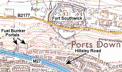
this time there have been many complaints from residents, and many reports in the 'Portsmouth News' of strange noises coming from 
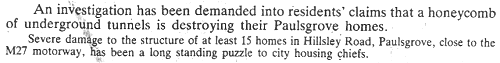
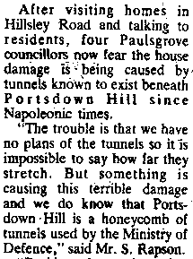
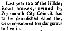
below the ground. Additionally at least 15 houses have been subject to subsidence, a problem which has never occurred in any other part of the estate, and which is almost unheard of when houses are built on chalk. Two properties were so badly affected that they had to be demolished.

What follows are various clips taken over the years from Portsmouth's local newspaper 'The News'.

News headline
 
 
News headline
 
 
News clip 01
 
 
News cutting 02
 
 
 News cutting 03
 
 
News cutting 04
News cutting 05


Here are some extracts from emails received about Hillsley Road. The italicised comments in [] brackets are mine.

NEW - 24-10-2004

I worked on the new flats in Hillsley Rd, I was told that when Simms builders where putting piles in to build the new flats on, they got one in about half way & it suddenly disappeared. Not sure if Simms builders are still in business to confirm this.


Darren Scott - October 2004


click the arrow


page 1 of 3

>