Naval Fuel Bunkers

 Created 04-12-2004   Last update 04-12-2004

<

Fuel Bunkers

page 3 of 3

>

 Fuel Pipeline


The fuel bunkers were subject to at least one German bombing raid during 1940 when incendiaries fell to the south of the southern compounds. A pig farm was hit and many pigs were burnt alive. Eye witness accounts say that Army officers arrived at the scene and prevented any fire-fighting  because in their view it would tell the bomber crews that there was something worth saving. The farm was allowed to burn down. Here is an extract from the Cosham War Diaries which recorded the event:

 
27th August 1940 21.06 to 2150 Hrs Incendiary Bombs fell on and around FORT NELSON, eventually the bombs spread eastwards, extending from FORT NELSON via SOUTHWICK to FORT WIDLEY along the top of the Hill and then due south into Wymering and along Southampton Road. Many 1,000s of ICBs [Incendiary Canister Bombs] were dropped by the enemy on the houses in "P" Group west of Portsdown School to Portsdown Road (Portchester) and Vosper's Yard were involved. In all 30 houses were ignited by the incendiary bombs. 6 were completely burnt out in Peterborough Road. 
Further west in Paulsgrove the Fort Southwick Married Quarters were also burnt out but with no loss of life. 2 Piggeries were set on fire causing trouble as horses were stabled in one, but the horses were got out but many of the pigs were burnt to death. The Night Shift at Vospers put out the several fires in the Shipyard . There was a shortage of water in Wymering so the AFS had to bring in "Mobile Dams" . Eventually all fires were brought under control . Most of the Bombs in those early days were smothered by shovels and earth and chalk.
From then on every effort was made to organise Fire Parties in each sector and instructing the public in fire prevention.


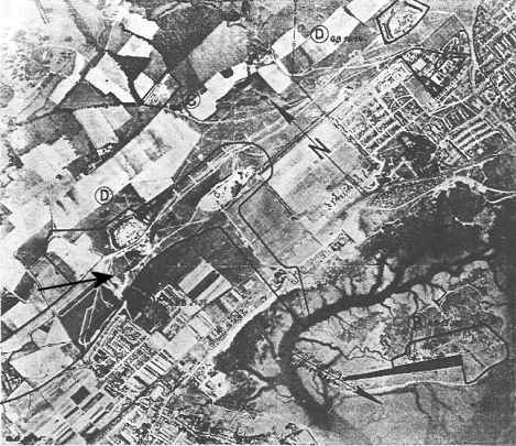
German Bombing Map

This is a German target map dated August 1940 which is believed to have been used during the 27 August 1940 raid.

It takes a bit of interpreting - North is indicated by an 'N' and an arrow shown just above centre right. Fort Southwick is left of centre with the 'D' above it. The Fuel Bunkers are to the left and below the fort which I have marked with a black arrow.

Google Earth Aerial View


Along with the map there is some text in German which identifies the letters A - E printed on the map (E is illegible). This is the text along with the English translation: 

A

Unterirdishes Tanklager Underground Fuel Depot

1

Pumpstation und Schornstein Pump Station and Chimney

2

Tanklager Paulsgrove Quay (3 kleine tanks) Fuel depot Paulsgrove Quay (3 small tanks)

3

Ölpumpstation Oil Pumping Station

B

Portchester Großfunkstelle Portchester high power radio station

4

6 Sendemaste 6 transmitting masts

5

Sendhaus Transmitter building

6

Verwaltungsgebäude Administration building
Gesamtfläche etwa 159000 qm. Total area about 159000 sq metres

C

 Schwere Flakstellung  Heavy Anti-aircraft position

D

2 Befestigungsanlagen der Portsdown - Linie 2 Defence  Portsdown Line 

E

Elektrische Umschaltanlage und Ferneitung Electric switching plant and overhead line

The Map Targets Identified

A - almost illegible. Just south of the Fuel Bunkers. This appears to confuse the Admiralty Fuel Bunker with the Paulsgrove fuel depot which was a small civilian concern. The target marker does not specifically indicate the Fuel Bunker and its very important strategic significance is not appreciated. The target marker is 300 yards south of the Fuel Bunkers portals:  the location of the Pig Farm.

 
B - almost illegible. Transmitting station on Horsea Island (bottom right) now absorbed by landfill into Port Solent. The black wedge shape was the Torpedo test tank, now a diver training facility.
 
C - 'Southwick' Heavy Anti-Aircraft position 
 
D - Forts Southwick and Widley
 
E - totally illegible. Probably the Electricity Sub-Station on the corner of Cow Lane and Medina Road at Cosham. (The black area to the left of the bottom of the 'North' arrow.

Contributors:

Peter Cobb


Mark Penfold


<

Fuel Bunkers

page 3 of 3

>

 Fuel Pipeline