|
|
|
This
was located to the east of the George Inn and is said by JH Cooke
in 'Tales
Of Ancient Wessex':
|
|
...it
is
the resting place of a young Bronze [Age] warrior, whose skeleton
was found associated with his flint dagger and food beaker; and
near by were found two flint 'cists' [pronounced
'kists'] containing the cremated
remains of his Neolithic predecessors... |
|
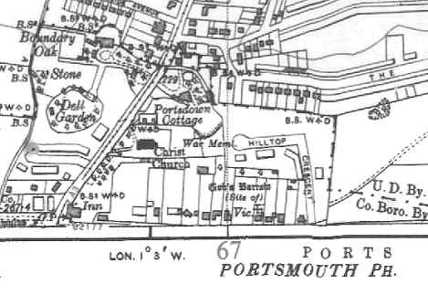
| When
the gradient at the George Inn crossroads was lowered in 1824
a number of of human bones were discovered, which indicated a
Roman burial. |
|
| |
| NEW -
05-04-2004 |
|
These
19th Century roadworks are interesting in their own right as at
one time it was proposed to construct a tunnel rather than a
cutting. Here are two extracts from the Hampshire Telegraph: |
| |
|
1819 July 10 - A Meeting of the Trustees of the Portsmouth and Petersfield Turnpike Road, was held at Horndean, on Monday last, when,
it will be heard with much satisfaction, it was resolved (on the motion of Joseph Smith, Esq. of Purbrook, one of the Trustees), to make the road at Portsdown Hill more easy to travellers, either by lowering the hill several feet, or by cutting a tunnel through it. As the latter plan will be attended with the least expense, by one thousand pounds, that, we understand, is most likely to be adopted: the tunnel to be 66 yards long, 17 feet high. This will be decided at a meeting intended to be held next week. The project, in giving employment to the poor, is of confessed importance; but, it will also prove highly beneficial as a public convenience - be an act of humanity, by lessening the labour of cattle - and of considerable importance to the occupiers of land in the neighbourhood, as affording an easy transmission of produce, manure, &c. - The plan will be carried into effect forthwith, as very sufficient funds, we understand, are in hand (surplus revenue of the Road Tolls), to accomplish it. |
|
|
|
1824 October 9 - The London Road, which has been recently lowered at Portsdown Hill, for the better accommodation of the Public, was
this day opened by a Committee of the Trustees of that Road. The whole of the road will be shortly completed. |
|
| |
|
Contributor: Geoff Salter |
| |
|
|
Aerial
photo site location Grid
Ref SU670065 |
|
|